
Table of Contents
Exploring the Changes in Historic Places: Incredible Then-and-Now Images – In this engaging article, we take a journey through time, uncovering the captivating evolution of famous historic spots using a collection of intriguing Then and Now Photos. These buildings, like silent storytellers, show us how these places remain constant amidst a swiftly changing world – an ongoing story with no end in sight.
Stroll through Rome, where tourists can reach out and touch the same Doric columns that were once within the grasp of Julius Caesar and Augustus. Step into Hiroshima, where a contemporary city has arisen from the ruins of a shattered community. These historical photos hold concealed insights about their subjects, and a closer look reveals changes in the surroundings, a world transformed.
Occasionally, these pictures also highlight unchanged aspects, an equally significant factor. These images demonstrate how communities honor their history, showcasing the careful preservation efforts. Online communities have emerged with a dedicated purpose – to carefully document these sites, capturing their gradual changes.
These historical accounts play a key role in comprehending the essence of a place, the values of its residents, and the impact of global events on local landmarks.
Arc de Triomphe’s Evolution from 1920 to 2015
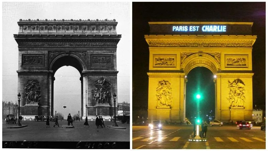
Witness the transformation of the iconic Arc de Triomphe in Paris, France, from the 1920s to 2015. This architectural masterpiece, initially conceived as a tribute from Napoleon to his valiant soldiers following the Battle of Austerlitz, has a rich history that ties it to both ancient inspirations and modern symbolism. Let’s delve into the story of this magnificent monument and its enduring significance.
Originating as a heartfelt tribute from Napoleon to his soldiers, the Arc de Triomphe was conceived after his triumphant return to France. Inspired by the Arch of Titus in Rome, Napoleon’s vision combined classical architectural elements with his deep admiration for his army’s bravery.
The Arch was strategically positioned at the heart of the Champs de Elysees, serving as a focal point where 12 roads converge, including grand boulevards that provide breathtaking views of Paris. Following some alterations by King Louis Philippe, the Arc was ultimately inaugurated in 1836, embodying a blend of historical homage and contemporary aesthetics.
In the present day, the Arc de Triomphe maintains its central position, surrounded by a bustling traffic circle that encapsulates the vibrant spirit of Paris. A poignant moment in its recent history saw the monument temporarily transformed into a canvas of unity.
The rallying cry “Paris est Charlie” was projected onto the Arc as a response to the tragic 2015 extremist attack that claimed the lives of eight staff members at Charlie Hebdo magazine. This symbolic gesture reaffirms the monument’s role as a canvas for contemporary expressions and a timeless emblem of resilience.
Eiffel Tower’s Timeless Presence: Avenue d’léna, Champs de Mars, Paris, Then and Now photos
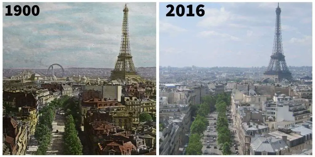
Embark on a visual voyage through the history of Avenue d’léna, Champs de Mars, revealing the transformative journey of the iconic Eiffel Tower in Paris, France, from its early days to the present. The Eiffel Tower, initially envisioned as a centerpiece for the 1889 Paris World’s Fair, holds a remarkable narrative that stretches across decades. Let’s immerse ourselves in the story of this celebrated landmark and the changes it has witnessed.
The Eiffel Tower had its genesis as the crowning jewel of the 1889 Paris World’s Fair. A symbol of innovation and elegance, it became a focal point that attracted visitors from around the world. As history repeated itself with the fair’s return in 1900, the Eiffel Tower reclaimed its position as the fair’s centerpiece.
However, a unique twist adorned this occasion: the tower was coated in a resplendent yellow-gold hue, a decision that set it apart. Drawing a staggering fifty million visitors, the fairgrounds showcased the creativity of 83,000 exhibitors, captivating all who attended. A notable addition to the scene was the appearance of a Ferris Wheel to the left of the Eiffel Tower in the 1900 image.
Originally introduced at the 1893 World’s Fair in Chicago, the Ferris Wheel’s popularity led it to become a beloved attraction at fairs across the globe, including the 1900 Paris Exhibition. Fast forward to 2016, where the echoes of the Paris Exhibition have faded, but the enchanting tree-lined avenue and the resplendent architecture that adorns it remain.
The Eiffel Tower, an enduring sentinel of Parisian splendor, stands tall as a testament to history’s embrace. Through the passage of time, Avenue d’léna, Champs de Mars, continues to thrive, encapsulating the charm of the past and the vibrancy of the present.
Barong Dance at Gunung Kawi, Tampaksiring, Indonesia, Then and Now photos
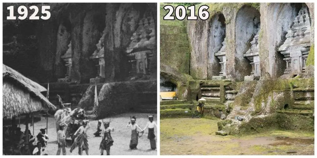
Delve into the enchanting tale of the Barong Dance at Gunung Kawi, Tampaksiring, Indonesia, as we compare its captivating presence in 1925 and 2016. Nestled near Bali, the 11th-century temple complex boasts remarkable monuments intricately carved into the cliffs.
Often likened to Egypt’s Valley of the Kings, this site pays homage to King and spiritual scholar Udayana and his royal legacy, including queens, offspring, and concubines. Let’s uncover the mesmerizing history of the Ten Gunung Kawi candi, a testament to memory, and the mystical dance that narrates its mythological tale.
Situated with grace in the Tampaksiring landscape, the 11th-century temple complex stands as a marvel, adorned with monuments etched into the cliffs. Often likened to the revered Valley of the Kings in Egypt, this sacred site reverberates with the legacies of King Udayana, a scholar and monarch, alongside his queens, progeny, and concubines.
A symphony of history and devotion, the Ten Gunung Kawi candi, or shrines, rise majestically, nestled within niches carved at an astonishing height of seven meters (23 feet). These candi, resembling portals, hold secrets beneath their surfaces, leading to small chambers that safeguard symbolic offerings, a testament to an era of veneration.
The 1925 image captures a mesmerizing scene as dancers weave the mythological narrative of Barong. Their dance embodies the essence of Barong, a lion-like figure symbolizing goodness. Often, these dances portray the timeless battle between Barong and Rangda, a manifestation of evil.
Today, Gunung Kawi remains a sacred sanctuary, yet its gates are open to the curious traveler. In a memorable moment, the temple hosted President Barack Obama during his 2017 visit to Bali, embracing the essence of history, spirituality, and modern diplomacy.
Beverly Hills Hotel’s Evolution from 1918 to 2018
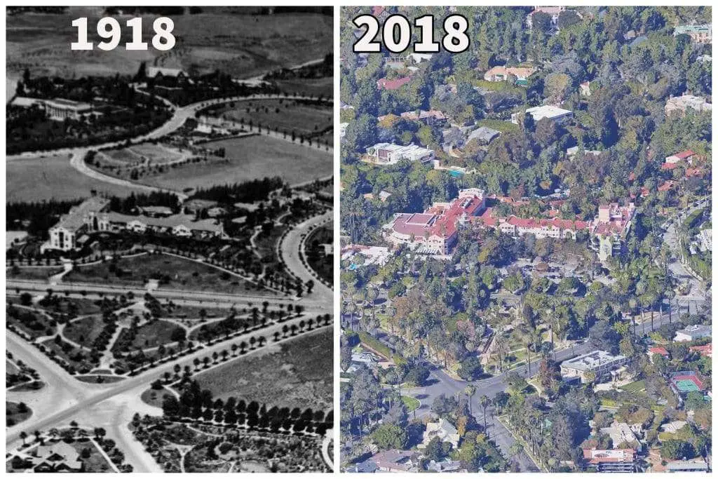
Delve into the captivating transformation of the Beverly Hills Hotel in the USA, as we journey through its history in 1918 and 2018. Long before the opulence of Beverly Hills took root, the Beverly Hills Hotel stood as a testament to the city’s origins.
Born from a vision of Burton Green in 1907, this historic hotel has played an integral role in shaping the allure of the region. Let’s embark on a journey to uncover the story of this illustrious establishment and its evolution over the years.
Originating as a complement to Burton Green’s ambitious Beverly Hills subdivision, the hotel emerged in 1912 under the guidance of Margaret Anderson. Positioned as a place for visitors to explore the burgeoning subdivision, the Beverly Hills Hotel was a precursor to the city’s incorporation in 1914.
This elegant establishment witnessed the rise of the iconic “Pickfair,” the home of famed celebrities Mary Pickford and Douglas Fairbanks, which stood in close proximity. Over the years, the hotel hosted a constellation of luminaries including Charlie Chaplin, Marilyn Monroe, John Lennon, and global royalty. The historic property held a rich tapestry of stories, each thread woven with the spirit of glamour and renown.
Throughout the decades, the Beverly Hills Hotel remained a sanctuary for the elite, embodying both luxury and history. However, the hotel faced a tide of controversy in 2014 when the Sultan of Brunei, the property’s owner since 1986, enacted changes in Brunei’s laws that incorporated elements of Sharia law.
This move drew international protest, including condemnation from the United Nations Human Rights Council. Despite the storm of debate, the Sultan retained ownership of the hotel, a symbol of resilience amidst turbulent times.
Evolution of Black Hills, South Dakota – Then and Now photos
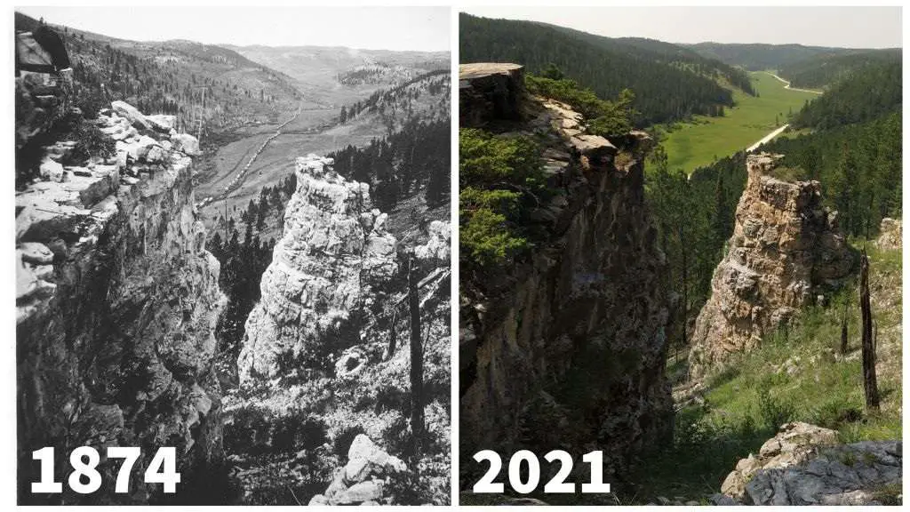
Here, we unveil the transformative journey of the Black Hills in South Dakota, USA, as we compare its past and present states. Back in the 1870s, these hills served as a gateway to the American West, setting the stage for adventures and explorations. Through a visual narrative, we delve into an 1874 scene depicting a wagon train’s progress across the landscape, showcasing a corduroy “bridge” under construction.
This method used logs to pave paths over swampy terrain. The wagon train was a part of the noteworthy Black Hills Expedition of 1874, led by General George Custer. It is a pivotal moment in the era’s Gold Rush history, meticulously documented through journals, reports, and photographs, providing a vivid glimpse into the Old West’s legacy. In our contemporary setting, a 2021 image illustrates the striking continuity of the modern road along the historic path of the Custer wagon train.
Transporting us to the 1870s, the Black Hills stand as a portal to the untamed American West. The 1874 image captures a wagon train making its way across the landscape, with photographer robertwellmancampbell noting the construction of a corduroy “bridge” downstream. These bridges, crafted from logs laid across paths, facilitated safe passage over wet terrain for vehicles, livestock, and travelers.
This particular wagon train was an integral element of the Black Hills Expedition of 1874, led by the renowned General George Custer. This expedition stands as one of the most meticulously chronicled events of the Old West era, illuminated through explorers’ journals, official reports, and the lens of photographer W.H. Illingworth.
Fast-forward to 2021, where our modern vantage point showcases the remarkable congruence between the present-day road and the historic path traversed by Custer’s wagon train. This visual alignment speaks to the enduring legacy of these landscapes and the journeys that shaped them, offering a captivating window into the interplay of time, progress, and heritage.
Evolution of Reykjavik’s Cabinet Building, Then and Now photos
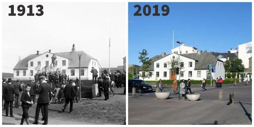
This captivating narrative delves into the historical transformation of the Cabinet Building in Reykjavik, Iceland, as we compare its images from 1913 and 2019. Through these snapshots, we gain insight into the changing times and the profound stories that have shaped the nation.
Our journey begins in 1913 when a man rowed a boat adorned with a blue and white flag around Reykjavik harbor. Although Iceland held its constitution since 1874, it remained under Danish rule. The flag represented Icelandic independence, a symbol that ignited a significant incident.
Amidst these struggles for autonomy, the iconic Cabinet Building became a focal point of protests against Danish military actions. Fast forward to our modern image in 2019, and we see a nearly unchanged building, yet the statue that graces it has transformed, reflecting Iceland’s triumphant path to independence.
In the year 1913, a boater leisurely navigated the waters of Reykjavik harbor, displaying a blue and white flag—a powerful emblem of Icelandic independence. Despite Iceland’s possession of its constitution since 1874, the nation remained under Danish dominion. The incident took an unexpected turn when a Danish man-o’-war halted the boater, objecting to the display of the Icelandic flag.
Icelandic Parliament swiftly reacted, declaring the arrest unjust and asserting that only the Icelandic flag should fly on the nation’s soil. The scene captured in the 1913 photo reveals a group gathered at the Cabinet Building to protest the actions of the Danish military. This chapter of history was set against the backdrop of Danish control, a tenure that extended until the German occupation of Denmark in 1940.
The journey towards Iceland’s cherished independence continued, ultimately culminating in 1944 when the nation formally broke free from its long-standing aspirations. Our modern image in 2019 showcases the Cabinet Building almost unaltered, a silent witness to the nation’s transformative journey.
However, a notable change is evident in the statue that adorns the building, transitioning from Danish King Christian IX to Hannes Hafstein, the visionary who served as Iceland’s first Prime Minister. This symbolic alteration captures the evolution from Danish dominion to the dawn of an independent Iceland, etching a vivid tale into the fabric of the nation’s history.
Calle Valentín Masip in Oviedo, Then and Now photos
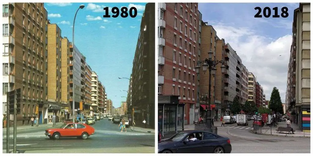
This captivating narrative unveils the evolution of Calle Valentín Masip in Oviedo, Spain, as we compare its images from 1980 and 2018. This bustling thoroughfare connects La Argañosa to the heart of the city, with a storied past that intertwines with Spain’s history. The 1980 street scene is lined with postmodern architecture, concealing the remnants of the Spanish Civil War and the Siege of Oviedo, events that took place just four decades prior.
Named after Mayor Valentín Masip Acevedo, a visionary in public infrastructure, the road’s transformation into a vibrant commercial and residential district is captured in both images. The passage of thirty years between the images reveals a street that underwent subtle physical changes yet a significant transformation in its functionality and essence.
Nestled in Oviedo, Calle Valentín Masip emerges as a bustling artery that links La Argañosa to the heart of the city. The 1980 scene portrays a street adorned with postmodern architectural facades that cloak the scars of the tumultuous Spanish Civil War and the Siege of Oviedo.
A mere forty-four years prior, the city had found itself aligned with the Nationalist side during these conflicts. The street’s nomenclature pays homage to Mayor Valentín Masip Acevedo, a visionary who championed public improvements, playing a pivotal role in molding the road into the vibrant blend of commerce and residence depicted in both 1980 and 2018 images.
The journey of transformation from 1980 to 2018 is subtle yet profound. The architectural facades remained largely unchanged, yet the street itself underwent a remarkable evolution. The widened sidewalks now host an inviting canopy of streetscaping trees, offering shade and a touch of verdant beauty.
Classical lanterns have gracefully replaced the gooseneck lights, and the introduction of benches invites pedestrians to pause and take respite. These changes, seemingly small, have collectively fostered a more pedestrian-friendly environment. Calle Valentín Masip’s narrative speaks to the fusion of history and progress, where architectural continuity meets the pursuit of community well-being.
Chichen Itza’s Journey on the Yucatan Peninsula, Then and Now photos
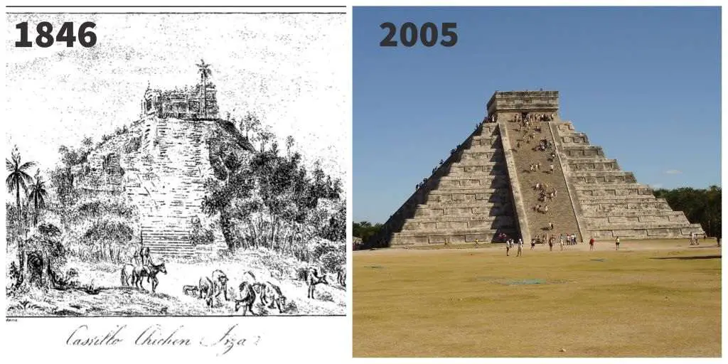
This captivating narrative takes us on a journey through time, revealing the evolution of Chichen Itza on the Yucatan Peninsula, Mexico, as captured in images from 1846 and 2005. The iconic stepped pyramid temple, El Castillo, stands as a testament to human ingenuity and history’s passage. Drawing 2.5 million visitors annually, it is one of the New Seven Wonders of the World.
We step back to an era when Chichen Itza flourished, with an estimated population of 50,000 during its peak in 600 CE. This urban hub was a thriving center, and El Castillo, dedicated to the snake-like spirit Kulkulkan, was its shining jewel. With meticulous alignment, the pyramid cast shadows that evoked Kulkulkan’s descent twice a year.
Centuries later, the Mayans departed, leaving El Castillo to the elements, as seen in the 1846 image. However, with dedicated restoration, Chichen Itza regained its splendor and welcomed visitors. The 2005 image reveals a dynamic shift, as visitors once could ascend El Castillo but now are no longer able due to preservation efforts.
The heart of Chichen Itza unfolds in the shadow of El Castillo, an architectural marvel that draws millions of modern-day pilgrims. Yet, stepping back to the height of its glory in 600 CE, Chichen Itza was a bustling urban nucleus that housed about 50,000 inhabitants, thriving on the Yucatan Peninsula.
El Castillo, the zenith of the Chichen Itza complex, was a spiritual cornerstone dedicated to Kulkulkan, the serpentine deity. Ingeniously aligned, the pyramid’s steps cast shadows that appeared as if Kulkulkan himself was descending, a testament to the Mayans’ mastery of both architecture and cosmic symbolism.
The 1846 image paints a picture of El Castillo, a once-vibrant monument, now left to the ravages of time and nature. The departure of the Mayans in the 1400s saw Chichen Itza’s decline, leading to its abandonment. Yet, from these ruins arose a phoenix of restoration. Chichen Itza welcomed a new era of visitors, offering a glimpse into its storied past.
The 2005 image introduces a dynamic shift as visitors once ascended El Castillo’s steps to embrace its history. However, the passage of time and the footfalls of millions took a toll. The decision to prohibit climbing El Castillo stands as a testament to the delicate balance between preservation and accessibility, ensuring this monumental legacy endures for generations to come.
Chrysler Building’s Journey in New York City, 1932 and 2006
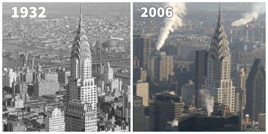
This narrative takes us on a captivating journey through the transformation of the Chrysler Building in New York City, USA, as captured in images from 1932 and 2006. A true marvel of the Art Deco movement, the Chrysler Building stands as a testament to architectural innovation.
From its geometric composition of squares, rectangles, and triangles to its majestic height of 1,048 feet, this iconic structure is a symphony of design and engineering. Rising to claim the title of the world’s tallest building in 1930, its reign was fleeting, as the Empire State Building took over in 1931.
Yet, the images from 1932 and 2006 hold more than architectural marvels – they encapsulate the evolution of New York City over a span of seventy-four years, revealing the ever-changing landscape and progress that characterize this dynamic city. In the realm of architectural marvels, the Chrysler Building emerges as a pinnacle of the Art Deco style, a masterpiece composed of geometric forms that weave intricate patterns.
The 1932 image, captured shortly after its completion in May 1930, showcases the building’s remarkable design, from its base adorned with squares and rectangles to the graceful arches formed by skillfully arranged triangles. Rising to an awe-inspiring height of 1,048 feet, the Chrysler Building briefly held the title of the world’s tallest building until 1931 when the Empire State Building ascended to claim the mantle.
However, the images from 1932 and 2006 transcend the realm of architectural achievements. They serve as portals to the dynamic transformation of New York City, illuminating the evolution of its Upper East Side neighborhoods near the Queensborough Bridge over seven decades.
The shifting cityscape paints a vivid picture of growth and development, with many of the 1932 buildings fading into history, giving way to new structures. The skyscrapers surrounding the iconic Chrysler Building, rising ever taller, stand as a testament to the relentless march of progress. These images, side by side, encapsulate the narrative of a city that thrives on change while preserving its iconic landmarks.
Coliseum’s Enduring Legacy in Rome, 1875 and 2015
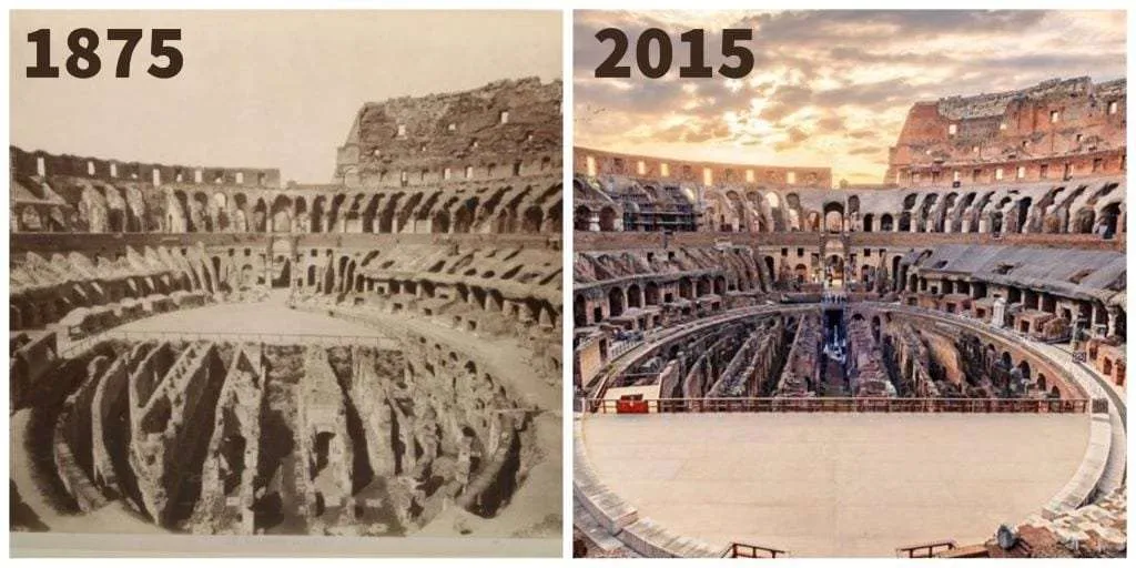
This narrative unveils the timeless journey of Rome’s Coliseum through the lenses of history, as captured in images from 1875 and 2015. For almost two millennia, the Coliseum has stood as a resolute testament to the grandeur of the Roman Empire. A living embodiment of Roman might, it bore witness to gladiator games, races, naumachia, and grand public spectacles until 523 CE. However, as Rome’s power waned, the Coliseum suffered neglect, abandoned to the ravages of nature.
Earthquakes, fires, and water damage took their toll, while the Dark Ages further depleted its resources as builders scavenged its materials for their own endeavors. Over time, the Coliseum’s roles transformed, from a cemetery to housing, a castle, shops, and altars. Its protection and restoration journey began in the 18th and 19th centuries under papal guidance, reviving its historical significance. Today, the Coliseum stands as a cherished tourist destination and cultural arena, hosting concerts, plays, and vibrant events that bridge the past with the present.
Since its inception, the Coliseum has been a monument to the Roman Empire’s might, a hub of grandeur and spectacle. Bearing witness to gladiator games, races, naumachia, and diverse public events, it reigned as a symbol of Roman prowess until 523 CE. Yet, as the city faced tumultuous times, the Coliseum’s fate took a somber turn.
Ravaged by earthquakes, fires, and water’s relentless embrace, the Coliseum succumbed to the passage of time. In the Dark Ages, the very stone and marble that embodied its magnificence were pilfered for other projects. This once-glorious arena morphed into a patchwork of roles, serving as a cemetery, residential space, fortress, markets, and even places of worship.
Yet, as history unfolded, the Coliseum’s fortune took an upward trajectory. In 1744, Pope Benedict XIV initiated the preservation movement by restricting the use of Coliseum materials for other ventures. The restoration fervor gained momentum with Pope Pius VII in 1820, heralding the beginning of efforts to conserve and revive the Coliseum’s splendor.
It even served as a place of worship, a church, until 1870. Today, this iconic structure stands as a thriving tourist attraction and cultural nexus. No longer relegated to the past, it resonates with vibrant life as it hosts an array of contemporary events such as concerts, plays, and cultural gatherings. The Coliseum’s journey, spanning centuries, encapsulates resilience, revival, and a timeless bridge between history and modernity.
You might also read:
5 comments
I couldn’t refrain from commenting. Exceptionally well written!
I feel that is one of the so much important information for me.
And i’m satisfied studying your article. But
wanna statement on some basic things, The site taste is wonderful, the articles is in reality nice :
D. Good process, cheers
When someone writes an article he/she retains the plan of a user
in his/her brain that how a user can understand it. So that’s why this article is amazing.
Thanks!
After looking at a number of the blog posts on your blog, I honestly
like your way of writing a blog. I added it to my bookmark website list and will
be checking back in the near future. Take a look at my web site as well and tell me your
opinion.
Wow! This blog looks just like my old one! It’s on a completely different subject but it
has pretty much the same page layout and
design. Great choice of colors!